Check-Ins
| When? | Who? | Comment | Place | Location |
|---|---|---|---|---|
|
the_crazzie_frazzie
|
As of today dump station still out of service. |
Speedway | 34.72209, -112.00245 | |
|
charlesmaxwell79
|
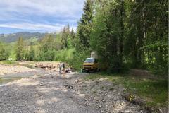
end of the Forest Road. There are plenty of campsites along the Forest Road but every one of them was full. I think I got the best spot. Only downside is you will have people turning around in front of your site. |
End of Forest rd | 32.91252, -105.72531 | |
|
||||
|
bberkovich
|
Amazing place to hunker down for the night. It's close to town, but quiet and above it all. You've got spectacular views of Pocatello. I fit a 26' class A up there without any problem. I wouldn't do much bigger. A few things to note:
|
Cusick creek trailhead | 42.83861, -112.45082 | |
|
||||
|
young.justin31
|
Forest service land, free camping, up to 14 day stay. Site is off dirt road west of strawberry reservoir. Rock fire pit. Spot can hold 4 vehicles. Site is next to atv trail surrounded aspen trees. Worth the venture. |
Horse creek | 40.15377, -111.21349 | |
|
||||
|
richardbretherton
|
Great spot, easy access, fire pit and fire wood. Some noise from people shooting at quarry close by but stopped late afternoon. Could fit a couple of smaller vehicles easily. |
Outside of bend | 43.86373, -121.39152 | |
|
||||
|
melcruja
|
close for covid
|
Plasket Ridge Rd over the fog | 35.90771, -121.46329 | |
|
baude.mathieu38
|
Pas dormi ici, mais si vous avez une tente traverser le pont sur le rivière et rejoignez le second parking avec un site de camping plus à l'abri |
Parking "point de vue" | 48.74342, -64.32858 | |
|
baude.mathieu38
|
Halte routière, avec un chemin de terre encore plus proche du lac au bout de laquelle c'est bien calme, même si la route est proche, peu de traffic |
Sunflower trail | 49.23604, -65.63439 | |
|
mitchell.epeneter
|
Fairly easy to find. Road was a bit slippery but doable with AWD in our Element. It’s definitely a local hangout spot to drink, shoot guns, party. Big pullout with great views but road noise and other people kind of ruin it. |
Trail Head and Power-line access. | 34.22233, -117.45965 | |
|
Family Off The Map
|
great spot off the highway, with some grass to put a tent. Also a few other sites along the road just past the trailhead. Very little highway noise |
lava hike trailhead | 43.55399, -112.44170 | |
|
||||
|
wildgranite
|
Description sums it up. Side of a dirt road. Nothing special, no tmobile service, only went up dirt road about a mile. Road in good condition as of now, pull off has room for 1 van size rig. Not good for larger rvs. |
side of dirt road | 39.56687, -120.74826 | |
|
manfiucast
|
Pretty large spot right next to the highway at the beginning of an OHV area. Nothing special but handy for a night. Easy access through a gravel road. More spots down the dirt road. |
OHV area | 34.31220, -116.80644 | |
|
dcawley
|
This is a great find. Stayed in the Big Branch Parking lot next to AT/LT Trail access. Very quiet and safe. |
FS 10 / Mt. TABOR | 43.35137, -72.97627 | |
|
Why Arent You Turning Left
|
We asked the fishermen if we could camp around past the blue building, past the lighthouse, they said Yes of course, no problem. It's a beautiful little spot to stay for the night. |
Mabou Harbour | 46.08598, -61.46571 | |
|
||||
|
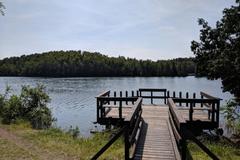
djkunze
|
The Hogback Lake Area has a rustic campground with 3 sites, a 5 mile trail system passing 6 lakes with several different loops, and 5 backcountry campsites along the trail. There is also a boat launch and an accessible fishing pier. |
Hogback Lake Rustic Campground & Backcountry Sites | 47.64444, -91.13589 | |
|
||||
|
instagram.com/bryceybrycey
|
Was very quiet, apparently no one knows of this spot because it was deserted on Labor Day weekend. There is a faint thumping in the distance which we think is an oil jack on an oil well nearby |
Recapture Pocket | 37.31667, -109.47278 | |
|
||||
|
gabrielvermette
|
no problem here, talked with locals and they said it was totally fine. We were three van and had no problem and an epic view in the morning..! |
Parc De L'anse Benson | 46.75339, -71.24898 | |
|
||||
|
Tino S.
|
A nice place at the Donau cycle path. 2-3 small tents are ok |
Donau Straubing | 48.90047, 12.57114 | |
|
ourlifeuntethered5
|
Gas station with a Subway. It has a dump station and water. |
Shell station | 39.82134, -111.83511 | |
|
ourlifeuntethered5
|
Gas station with RV dump and water and propane. Dump is $5. |
Chevron Gas Station | 40.08611, -111.59302 | |
|
milesmcbeam
|
Had some trouble finding the road since it's not on Google Maps, and my 51 year old VW headlights might as well be on the back of the bus. But seems like a decent place. |
BLM Land | 34.44113, -114.22383 | |
|
koureasn
|
not suitable for tents, the roads to and from are hazardous |
Nice place next to the river, with waterfall nearby | 37.69890, 21.80896 | |
|
skye.hendrix
|
Nice remote place! Lake was flooded. Arrived late and left early so didn’t get to enjoy scenery as much as would have liked to! |
Ashley Creek | 35.10677, -93.70850 | |
|
||||
|
eli.recon
|
There is a water spigot by itself on the grass in this park that will fill your container at a very fast rate. At least one local said it was spring water. |
Park water spigot | 38.84385, -106.13403 | |
|
timjames.leu
|
Beautiful spot right next to the river. Enough space for three campers and two or three tents.
|
Fireplace by the river | 46.81153, 7.91711 | |

|
||||
|
suppi_tossu
|
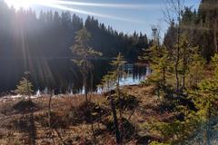
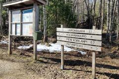
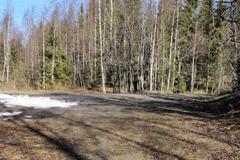
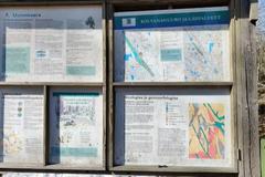
Parking spot at the beginning of a Kolvananuuro track. Peaceful place in the middle of the woods. Room for at least five to eight cars. Might be hard to reach with a large car or a trailer. We made our way with a van okay. Road has signs to the spot "Kolvananuuro". fireplace 0,7km away (hiking) with a outdoor toilet. The track is very steep, but it has some ropes in the most challenging bits. In the bottom of the track it has a beautiful pond, which you can circle. The track has some other parking spots, so they might be worth a visit as well. Probably not available during winter. |
Spot at the beginning of a track | 62.86225, 29.98012 | |
|
||||
|
BeardoMcGrath
|
Intended to visit this site for a night, but camped farther south along the access road instead due to a large party already there (busy for Memorial Day Weekend). Some mud right before the campsite might be difficult for low clearance vehicles. Nice area, and quiet. |
McClendon Springs Rec Area | 42.33579, -113.40664 | |
|
fanny.gallagher.cohen
|
This is a great little spot with pit toilet and more than enough space to take your dog for a lap and have a picnic on the tables. Looks like a fishing spot for locals. Safe and quiet |
Waterfront park | 42.68405, -82.70915 | |
|
||||
|
sfedov
|
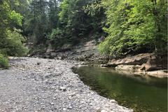
Great spot to explore the dried lake. Beautiful views.
|
Nice picnic spot near Humboldt Lake | 40.07528, -118.57481 | |
|
||||
|
sfedov
|
Gravel road off the road-95. About 1-2 miles in, several felt isolated spots to camp.
If wet/rainy, good chance to get stuck - the mud is super slippery. No cellular service. |
Gravel Road. Old 10N Highway | 42.82610, -117.67836 | |
|
||||