Check-Ins
| When? | Who? | Comment | Place | Location |
|---|---|---|---|---|
|
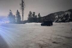
lsgrench45
|
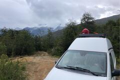
Relatively flat, plowed relatively often in the winter too. Good spot if you’re skiing in Jackson. 15-20 minutes to the Stilson lot. |
Turnout | 43.49718, -110.94813 | |
|
||||
|
nursewendy60
|
Asked if we could spend the night, no problem, told us to park beside the OXXO in front of a couple of trailers. Uneventful night, some traffic noise but nothing to complain about. |
Pemex Gas Station | 17.98984, -102.22504 | |
|
mwavesdave
|
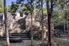
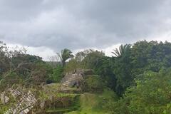
We were expecting to be turned away at the checkpoint, as we have our dog with us. The men certainly did see our dog, but we passed without problem. Ruins themselves are of course off limits to dogs, but we were early in the morning, nice cool shaded spots to park. We saw the amazing Ruins, as well as Toucans, Turkeys, Monkeys, Javelina, and many bird species. |
Calakmul ruins | 18.11451, -89.80116 | |
|
||||
|
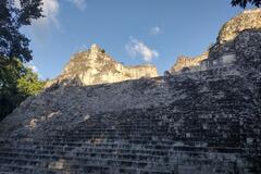
mwavesdave
|
Hardly anyone here, so we had a great time wandering. Very worthwhile. |
Becan and Rio Bec archeological sites | 18.51932, -89.46568 | |
|
||||
|
backpack.diary
|
Very nice place, we stayed at the end (for vehicles), no wind and beautiful view on the crystal clear water and the glacier, wauw! Another campervan under the big tree and a cyclist on the beach. Movistar 3G worked well. Véry quiet night, didn’t hear anything. |
Lakeside | -46.84662, -72.80704 | |
|
||||
|
teacherpaja
|
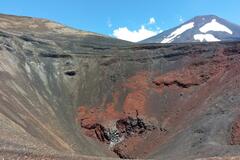
Stunning views. Nice and easy hike, remember you are exposed the whole time. |
Cráter Navidad hike | -38.38120, -71.54835 | |
|
||||
|
magda.marco
|
Price is 1000 pesos pp and 600 pesos for the campervan. |
Camping Municipal Cachi | -25.12265, -66.16717 | |
|
geroctapusssy
|
They charged 5 soles for the stay.
|
Girasol | -3.57276, -80.46305 | |
|
xicomotos76
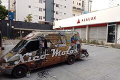
|
local de fácil acesso e o proprietário Sr Donato é muitíssimo prestativo |
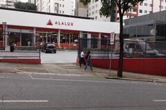
Alalux Lighting Store - Parking Lot | -15.57516, -54.32601 | |
|
||||
|
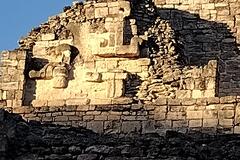
Sillyng_around
|
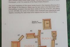
Nice and well preserved Mayan ruins. You're allowed to climb to all buildings, you can also visit a pond a short walk away trough the jungle. Little museum with interesting information regarding the region and the old town social structure. The entrance is 10bz pp for non residents. The place is clean and well taken care of, free parking (outside of the arqueological area), clean bathrooms, guide service is offered (we didn't ask the price), and small souvenir shops on site. |
Altun Ha Ruins | 17.76629, -88.34592 | |
|
||||
|
sharpsusan
|
we paid $100 pesos total for two people and our campervan. $5 pesos to use the restroom while it's open. restaurant Karen was pricy but tasty. not too many people out. beautiful dolphin. |
Whale Watching Parking Lot | 25.19404, -112.12313 | |
|
Colleen_JördTheVan
|
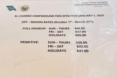
Came in late (around 9pm) and found a primitive spot with no reservation and pulled in for the night. Primitive spots were mostly sloped/full hookups looked significantly flatter. As expected, we woke up to a courtesy reminder on our windshield for the spot. Fees were pricier than we expected so posting them here for more context. Wish we could have enjoyed the rest of the park for this price! Has botanical gardens, but the rain made that a no-go for us. Highway noise but plenty of spaces (this time of year). |
El Chorro Regional Park Campground | 35.33138, -120.73094 | |
|
||||
|
Pachific_around_Africa
|
This place does not officialy exist as a camp site. The guy Maurice charge 5 USD per night per person. There is no facility. He is working for Nanas Lodge and the place does not belongs to him. |
Surf Point Campsite | 6.74932, -11.38130 | |
|
frank.neikes22
|
Esteban lugar se Llama Mr.cafe
|
mister cafe | -14.83362, -64.90732 | |

|
||||
|
mmq-photography.com
|
Nice campsite in the woods, close to the viewpoints Laguna Sucia and Lago de Los Tres. Basic, with two pit toilets. A bit bigger than Agostini campsite. Potable water from the river Blanco. Again, can't believe it's free, in Torres del Paine Nationalpark they charge you 50 $ for almost the same! |
National Park campsite Poincenot | -49.28258, -72.96134 | |
|
mmq-photography.com
|
Easy hike, about 10 km one way from El Chalten. A lot of day hikers. You can do it as 3 day hike, and stay at Agostini and Poincenot campsite (free), to have less croud and better photography light. |
Laguna Torre | -49.32994, -72.98924 | |
|
mmq-photography.com
|
Easy hike, about 10 km one way from El Chalten. A lot of day hikers. You can do it as 3 day hike, and stay at Agostini and Poincenot campsite (free), to have less croud and better photography light. |
Laguna de los Tres | -49.28124, -72.98326 | |
|
mmq-photography.com
|
Beautiful viewpoint of Mt. Fitzroy. It's not that crowded as Laguna de Los Tres. The path is marked with stones, sometimes a bit rocky, and one river crossing, but okay (~1.5 hours if you take it easy). Just follow the signs to Laguna de Los Tres and turn left after having crossed Rio Blanco for the second time after the campground Poincenot (at the wooden bridge). Be careful, there's another path after the first crossing but you won't make it over the river later on without getting wet 😬 |
Viewpoint Laguna Susia | -49.28639, -72.99034 | |
|
cordian
|
Nice and hot shower. We didn't have to pay. In the men's bathroom there is no privacy, but nice and hot showers. Woman's bathroom is more private but a bit colder. |
YPF | -54.79018, -68.22662 | |
|
cordian
|
Really nice place. It is free and there is a bathroom that seems to be cleaned every day. The police coms in every now and then to check for fire. |
Municipial Campground | -54.77946, -68.26993 | |
|
elixmia
|
7.000 per person per night. This is a fairly small campsite with one grassy area for tents and a different one for vehicles - of which you could fit two at most. Anything bigger than a truck camper will probably not fit. Wifi is good, but doesn’t reach the vehicle parking area. The shower is good - very hot! Toilet is clean, but remember to bring your own toilet paper. Also a headlamp to use the toilet at night. All in all it’s a solid place to spend a few days. |
Camping El Pescador | -43.18487, -71.86327 | |
|
asauvageau67
|
Bel endroit avec vue sur les montagnes. Toilettes pit très propres. Tout près de Borrego Springs. Le dodo se fait dans un calme absolu !!!!! |
Peg Leg | 33.29659, -116.29774 | |
|
||||
|
benik000
|
Only stayed 1night very safe lots of hotel around there and nice restaurants, few min walk and there is a food places with playground for kids! Instagram: viagensdaste |
Sitio de Conde | -11.85560, -37.56564 | |
|
lesmilav.canalblog.com
|
Superbe endroit au bord du salar pour passer la nuit. Attention en janvier la température est descendue à 0 la nuit. |
salar de huasco | -20.28269, -68.89027 | |
|
matthew-shields
|
Really lovely camp. As others have already said, if you want a camp with a relaxed communal vibe, then definitely come here! They have some activities in and around the camp on the river, and Rupert can help arrange a trip to Nata Bird Sanctuary via Nata Lodge. We camped and prepared our own food, but Rupert had a braai going and was happy for us to use it when we got back from the pans, he got it ready for us!
|
Eselbe Camp | -20.19231, 26.18626 | |
|
Alexandre Sampaio
|
Espaço de acampamento no encontro do Rio Vinte com o Rio das Antas, muito visita pela comunidade local durante o dia. Calmo a noite. Acesso por rodovia de terra estreita, apenas para veículos menores de 7 metros. Muita natureza e aves silvestres. Tem local para banhos no rio. |
Rio Vinte | -29.06295, -51.42895 | |
|
||||
|
jnjcater
|
This was a great stop - easy access off 1 as stated in description. Followed the navigator on iOverlander app and it was perfect. Don’t stop at the first few areas on the dirt road, due to lots of trash, go farther down the dirt road and there are multiple great spots. The whole area seem to have a few stickers, but totally fine. Heard a few trucks going by on highway but otherwise not a peep of anything else. Also had great cell phone service! Haha Would definitely stay again! |
Cactus Jack | 27.41574, -113.24961 | |
|
||||
|
bloodhound89
|
Called and asked permission to stay in our camper van and was told it was okay. It’s a large lot but a busy one so a large RV might have a problem finding a spot. They have rv designated spots but we saw lots of regular cars just using those spaces instead. We were able to find a nice level spot in our van though. Stayed two nights. Quiet nights. Would stay again. |
Cracker Barrel | 37.52882, -77.35646 | |
|
pnoguera1340
|
Excelente lugar, muy tranquilo. Los baños impecables, las duchas con muy buen caudal de agua y bien caliente. Las parcelas muy comodas, aceptan mascotas. Se permite el ingreso para fogones, un grupo de jóvenes estuvieron hasta las 0 hora con música fuerte, pero luego dormimos muy bien. Nos costó 1500 la parcela, fuimos en camioneta. |
Santa Cruz Municipal Camping | -50.02555, -68.54233 | |
|
||||
|
grahamdoescher
|
The listed spot is a helicopter lift away zone with a no parking or camping sign posted, but along the road there are other large spots |
Large dispersed site up road from Reeher’s | 45.71528, -123.34344 | |