Check-Ins
| When? | Who? | Comment | Place | Location |
|---|---|---|---|---|
|
Dejando huella en familia
|
We stayed 1 night, good place, nobody bothered us. The old cars are a very nice decoration. No time limit or signs prohibiting overnight.
Nos quedamos una noche aquí, buen lugar, nadie nos molestó. Los autos viejos son una bonita decoración del lugar.
|
Rest Stop at MP 1295. | 60.49062, -133.29553 | |
|
petr.kunes(NissanX-trail)
|
Highway rest area with toilets, free hot shower and picnic tables. |
Area de descanso, free showers | -35.31721, -71.53433 | |
|
petr.kunes(NissanX-trail)
|
Highway rest area (Area de descanso), with parking lot, toilets, hot showers and water. It's quite hidden, just few meters behind the highway exit turn right. It's very noisy from the road, but very few cars stops here. |
Highway rest area | -35.31721, -71.53433 | |
|
Calimero
|
Can be accessed one way or the other. Dump station is on the middle of the road. Accessible for any rig. Very clean, so l'êtes keep it like this. Potable water and rinse water. |
West Valley Granger Community Dump Station | 40.70668, -111.97800 | |

|
||||
|
42.sweeney
|
Best rim repair shop I have come across in Mexico. 350p to fix the patch job I had done in Tijuana. Not sure the guys name but was recommended this place. Don’t go anywhere else |
Rim repair Welder | 17.98531, -102.22874 | |
|
yogawithshei
|
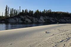
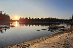
Fantastic spot.
|
Michipicoten canoe route | 47.92180, -84.80733 | |
|
||||
|
Wheretheroadtakesus
|
Found just as described. Very easy to get to. |
Cahone park | 37.66713, -108.80947 | |
|
Kenbo
|
Spot wasn't super level, but had decent ATT and was pretty quiet. On the weekend there were lots of dirt bikes/ATVs and people shooting. During the week there were some logging trucks passing by. Also you have to drive up a steep switchback road to get here with big drops on edge of road, but road conditions are great and pretty much any vehicle can make it. |
end of a logging road | 42.99724, -123.42927 | |
|
Registro de Viagem
|
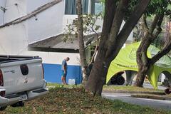
🇺🇸 At the police station there is a drinking water faucet, ask the police on duty before using it. 🇧🇷 No posto policial tem uma Torneira de Água potável, peça ao policial de plantão antes de usar. Youtube.com/@registrodeviagem.oficial |
Water Faucet at the Police Station | -22.95498, -43.06926 | |
|
||||
|
Hibiscus
|
it looked very closed....and both phone numbers dus not work. we did go to hotel Santa Teresa calle 3 with a safe parking lot for
|
Camping La Casa de los Sueños | 2.60837, -76.38383 | |
|
mikew
|
Same deal as the Draper Rec Center south of here - $2 showers (between 12pm-2pm only?) or $7 for a full day pass. Big locker rooms with showers, or a couple family restrooms with completely private toilet, sink, shower. |
Dimple Dell Recreation Center | 40.55754, -111.86463 | |
|
versal1994
|
Herman Creek Rd turns into Wyeth Rd on the Historic Route. There’s a lot of good turnouts & some were already occupied.
|
Wyeth Road TurnOuts | 45.69242, -121.82565 | |
|
samdstorm
|
Still a good place to dump! And super friendly staff. |
Marborg Industrie | 34.42232, -119.69865 | |
|
khalaf.decastro
|
As of today entrance is 10,000 Ar$ per person and because of winter season you need either chains or studded tires, "regular" winter tire are not enough
|
Perito Moreno Glacier | -50.42650, -72.75163 | |
|
ALL
|
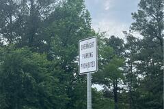
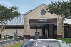
Usual rest stop with bathrooms, dog walk and vending. Signs posted everywhere for no overnight parking. |
Rest Stop #34 | 34.56342, -84.94442 | |
|
||||
|
tamikaharton
|
There's a locked gate, no entry ⛔ I had to turn around. Google photos on map are old, don't rely on them. |
‘’L’anse aux Sauvages’’ | 46.82578, -71.15567 | |
|
pjrollingon
|
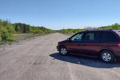
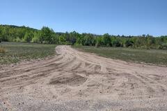
As described, great overnight spot, good gravel road to entrance which was easily passible in my minivan.
|
Louse Creek Air Stip (Abandoned) | 45.11033, -77.25885 | |
|
||||
|
Bill Nangle
|
Small gravel parking lot. No facilities, but will do for one night. |
K&P Trail Parking Lot | 44.31757, -76.58609 | |
|
morvis070966
|
Road closed & restricted. Gate closed & parking full at entry |
Little Bear | 45.52998, -111.13352 | |
|
marieclaude.chouinard
|
1$ for a shower, you just have to register. Showers was clean and hot. |
YMCA | 37.28176, -79.94151 | |
|
CrazyB
|
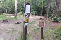
The second designated campsite along Headwaters road next to a creek. Metal fire ring. No other amenities. intermittent to no cell service on AT&T, but I went up the road just a little and got 4 bars |
Headwaters road designated campsite 2 | 35.31732, -82.80516 | |
|
||||
|
louis.ligaulthurel
|
20 dollars / 17.5 euros (350 pesos in 2023) for a double bed room, hot water, nothing fancy but doing the job. almost double the price if you want AC but for me the heat wasn't too bad really (depend of the season I guess) big secure parking, no pool nothing fancy, did the job very well. |
el mixteco | 18.32757, -98.26721 | |
|
vivienogden
|
Great sports complex, admission 4$ for swimming, undercover parking high enough for RVs |
Chavez Community Centre | 35.64039, -105.99200 | |
|
benpecover
|
There is a private property sign here. We moved on |
petite route sans issue | 48.40302, -70.52817 | |
|
3weltreisen.de
|
it is the parking lot Suborbia, they close at 9pm. it is not that quite at night, both mainroads and a thoroughfare road between Santander and suborbia Shop. many traffic and train noises. the only parking possibility for big rigs, easy to go by public Bus to the historic Center. |
Cordoba | 18.90219, -96.95842 | |
|
liz.vickersdrennan
|
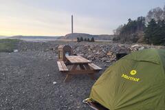
BEAUTIFUL spot. down a very short gravel road (easily feasible in a regular car) off the main drag. we were tenting and had loads of space (flat too). Had a nice quiet and undisturbed night. |
By the river and ocean | 49.01033, -58.13315 | |
|
||||
|
Calimero
|
Nice and clean, big parking lot on the other sidd of the building beside base-ball field that can accomodate any rig size. Parked there with a 25' travel trailer without any problem. The only thing is that shower only hours are a little bit restrictives, but I'm not complaining, it's $2 per person.... |
Redwood Rec Center | 40.70464, -111.93722 | |
|
bikevoyagers.de
|
Not a nice place. All covered with trash, the waterline was covered with thick black, slimey seaweed. So we left. |
Public Beach - South of Riversdale | 16.66842, -88.30921 | |
|
smifam.js
|
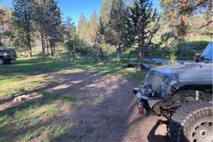
Large open area next to natural creek. Large fire pit with plenty of room for multiple vehicles and trailers. |
Spring Creek | 43.75698, -119.34082 | |

|
||||
|
smifam.js
|
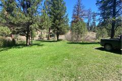
Nice quiet meadow off gravel service road. Large open space with green grass and pine trees. Gentle creek on the lower end. |
Bear Creek | 43.95894, -119.25316 | |

|
||||