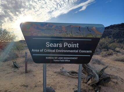
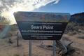
Sear’s Point (BLM) | Wild Camping
United States
WARNING: THIS PLACE IS PERMANENTLY CLOSED!
Details
- Verified:
- about 1 year ago
- GPS:
- 32.92853, -113.37054
- Altitude:
- 131.2 masl
- Website:
- None
- Contributor:
-
 Howard Snell

Amenities
- Electricity:
- No
- Wifi:
- Yes - Average
- Kitchen:
- No
- Restaurant:
- No
- Showers:
- No
- Water:
- No
- Toilets:
- No
- Big Rig Friendly:
- No
- Tent Friendly:
- Yes
- Pet Friendly:
- Yes
Something not right?
Description
iOverlander cannot verify if wild camping is permitted at this location. It is your responsibility to verify local laws or obtain consent before staying the night.
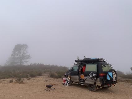
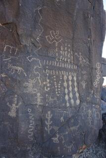
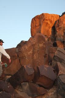
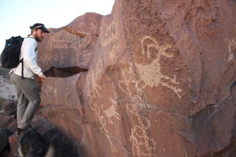
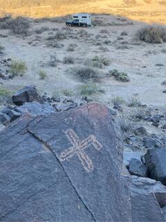
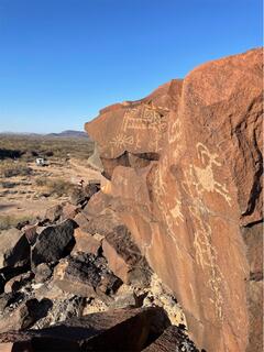
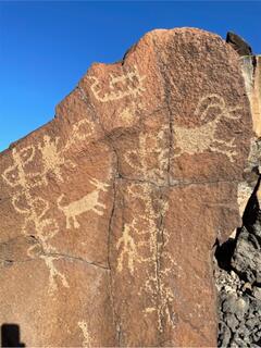
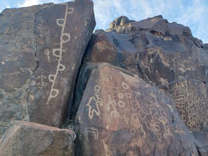
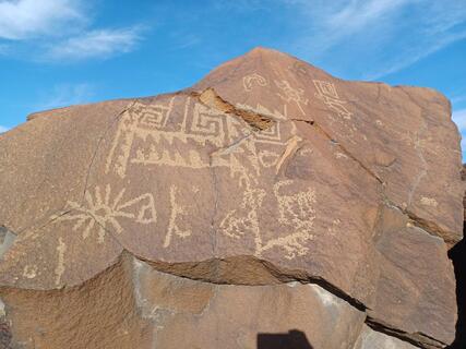
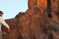
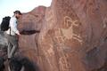
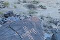
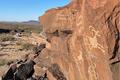
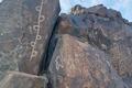
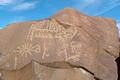
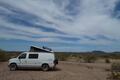
While not particularly convenient, dispersed camping OK and the petroglyphs are spectacular. We arrived in the evening & spent the next day scrambling basalt cliffs looking at literally thousands of petroglyphs then stayed a second night. No facilities, road rough & sandy in spots(4x4 & truck high clearance recommended), but worth it if you like rock art. We visited in winter, suspect it could be unbearably hot in summer as almost no shade. Flats and track at site would be impassable if muddy. One or two bars of weak Verizon coverage in January 2020. Appears as though only access from S via Spot Road exit on I8 then S Avenue 76 (don’t let the urban sounding name fool you).
Photos


Why? By checking in after you’ve visited a place you let others know this place is still functional. You can also add or correct any information.
Latest Check-Ins
About 7 miles in from I-8, the dirt road is now impassable due to a washout. A cycle could get by, but not a 4-wheeled vehicle.
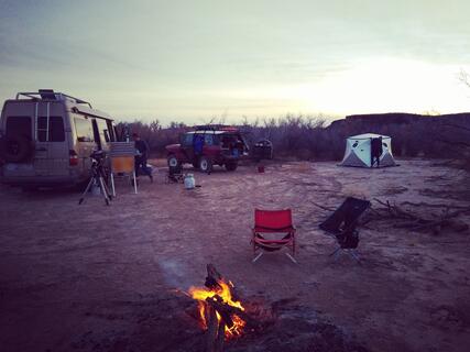
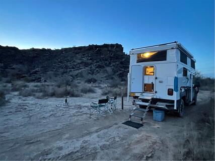
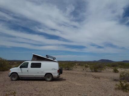
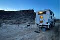
Report Check-InWe're camped near the end of the all-weather road, before the mud flats - a 20 minute walk to the Petroglyph site.
This is a big, level space with an established fire ring. Nice views.
NPR at 88.9.
Report Check-InAs described by everyone else. I came two days after some rain and the road had some soft spots but nothing too serious. I wouldn't drive all the way down if there was rain in the forecast.
Report Check-InExcellent experience. Only six miles from I-8 yet very remote, absolutely quiet and the petroglyphs are amazing. Higher clearance vehicle recommended. Don’t bring a motor home here. The first five miles from the freeway frontage road, Avenue 76 East, is fairly straight and improved. The last mile in is the tricky part w/ previously mentioned sand and a couple small wash-outs. Walk it if in doubt then bring your vehicle along slowly. There’s plenty of camping spots along the way in as most of the land on either side of the Road is public; either BLM or Arizona Trust. There is a piece of private land but the fences, buildings and trailers make it very obvious. There’s at least 2 bars of AT&T all the way in. As this is written we are camping at the basaltic rocks near the trailhead and yes, the fine dust described is everywhere. The actual site is on the ancient floodplain of the Gila River, which ran silty and strong until several dams were constructed far upriver in the early 20th century. No flood danger, yet next time I’ll camp at the higher ground at the old river bank a couple hundred yards back and drive in to the glyphs. As others described, hiking in would be an easy affair.
Report Check-InBeautiful petroglyphs spread along 2 miles of cliff face. Powdery clay dust gets blown around if you camp in the immediate area. Better camping up on the ridge before descending to the trailhead. Road has an off cambered washout about 2.5 miles before the trailhead. Though passable by most vehicles, we decided not to drive it with our full size 4x4 truck camper. We camped at the washout and hiked on the next day. Great hike through the desert. washing
Report Check-InWe were septical if our astrovan non 4x4 would be able to go down that road and it did! We do have good tires. It was a restful night and an entire morning expedition in the petroglyphs! go down completely off the road even if Google map tells you it stops before. Have a good visit!!
Report Check-InExit 78 on I8 Spot Rd. Turn right onto frontage road. 1 mile. Left onto Ave 76. Drive to end. High clearance needed. Some near washouts towards end. Definitely worth a visit.
Report Check-InBeautiful petroglyphs! Lots of fun. Be carefull if you camp on spot of the bed river. There was a lot of rusted wires on the spot were I was. I pickep up the one that I have seen and put it altogether in a bush.
Report Check-InRoad was fine, might need high clearance a few spots but no 4wd needed. The petroglyphs are abundant and spectacular. Unfortunately it was extremely windy, which resulted in a lot of blowing dust which got in everything. We saw nobody the whole time.
Report Check-InWe were basically in the same place. One mile from the end of the road at Sears Point. Nice hard pan camping, good Verizon coverage. Nice hike in the rock art. Takes 30 minutes to get here on dirt road. A few ruts require a bit higher clearance. No one here on a Friday in February.
Report Check-InExcellent petroglyphs! Vegetation has grown up and blocked the road to the original waypoints, but plenty of places to camp. Very dusty. We brought a two wheel drive Sprinter, but there has not been any rain or any in the forecast. My Land Rover would struggle when wet. Lots to explore here and well worth the effort.
Report Check-InFree, road in decent shape, lots of wild camping spots. The petroglyphs are absolutely stunning.
Report Check-InWhile not particularly convenient, dispersed camping OK and the petroglyphs are spectacular. We arrived in the evening & spent the next day scrambling basalt cliffs looking at literally thousands of petroglyphs then stayed a second night. No facilities, road rough & sandy in spots(4x4 & truck high clearance recommended), but worth it if you like rock art. We visited in winter, suspect it could be unbearably hot in summer as almost no shade. Flats and track at site would be impassable if muddy. One or two bars of weak Verizon coverage in January 2020. Appears as though only access from S via Spot Road exit on I8 then S Avenue 76 (don’t let the urban sounding name fool you).
Report Check-In