Cerro Pelon- Monarch Butterflies & Viewpoint | Tourist Attraction
Mexico
Details
- Verified:
- about 2 years ago
- GPS:
- 19.39171, -100.26311
- Altitude:
- 3500.0 masl
- Contributor:
-
 traventureside.wixsite.com

Amenities
Something not right?
Description
Annual migration of the Monarch butterfly (late Oct-Mar). See thousands of monarchs gather here, less touristy area to view them.
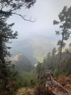
Start hike from Marcheros, see maps.me. End of trail on maps.me is not the actual end. You can continue on to the top of the mountain where there's a large cross (pictured) and a really nice viewpoint. 2hr to end of maps.me trail, plus 45min to the top from there. 2hr down from the cross at the top, above average fitness. Note you will get lost several times and do some bushwacking. Butterflies don't seem to land often so 99% of them you will see above you rather than covering the landscape.
To Get to the top, go to the end of the trail on maps.me, then Bushwack to the point labeled as Cerro Pelon peak. There you will find a trail to get to the top (very easy to follow this trail compared to the rest of the trail up to this point). Enjoy the viewpoint and thousands of butterflies flitting above you on the way up
Reservation is closed since Covid, so ignore the sign saying to pay a fee and guide required. Maps.me or other offline map definitely required
Why? By checking in after you’ve visited a place you let others know this place is still functional. You can also add or correct any information.
Latest Check-Ins
We came to Macheros to go see the butterflies. NOTE THAT THIS SANCTUARY IS CLOSE THIS YEAR (2022). The 3 others are open. Or, you can go to El Campamento (where we went). We were taught that it is not close because of COVID, but because a forest exploitation starts recently... a bad one. Maybe by not-so-kind-but-powerful people. So they want to "hide" it. Cerro Pelon was the last enterely preserved forest. Maybe we assist at the beginning of the end... So sad.
Report Check-InAnnual migration of the Monarch butterfly (late Oct-Mar). See thousands of monarchs gather here, less touristy area to view them.
Start hike from Marcheros, see maps.me. End of trail on maps.me is not the actual end. You can continue on to the top of the mountain where there's a large cross (pictured) and a really nice viewpoint. 2hr to end of maps.me trail, plus 45min to the top from there. 2hr down from the cross at the top, above average fitness. Note you will get lost several times and do some bushwacking. Butterflies don't seem to land often so 99% of them you will see above you rather than covering the landscape.
To Get to the top, go to the end of the trail on maps.me, then Bushwack to the point labeled as Cerro Pelon peak. There you will find a trail to get to the top (very easy to follow this trail compared to the rest of the trail up to this point). Enjoy the viewpoint and thousands of butterflies flitting above you on the way up
Reservation is closed since Covid, so ignore the sign saying to pay a fee and guide required. Maps.me or other offline map definitely required
Report Check-In