Henry Gray Hurricane Lake WMA | Wild Camping
United States
Details
- Verified:
- over 1 year ago
- GPS:
- 35.23095, -91.48211
- Altitude:
- 68.1 masl
- Website:
- None
- Contributor:
-
 caleb.dupuy86

Amenities
- Electricity:
- No
- Wifi:
- No
- Kitchen:
- No
- Restaurant:
- No
- Showers:
- No
- Water:
- Non-Potable
- Toilets:
- No
- Big Rig Friendly:
- No
- Tent Friendly:
- Yes
- Pet Friendly:
- Yes
Something not right?
Description
iOverlander cannot verify if wild camping is permitted at this location. It is your responsibility to verify local laws or obtain consent before staying the night.
Camping
There are 35 campsites available to the public on the WMA. All sites are primitive and are maintained by area personnel. The sites are marked by signs and/or ringed by blue paint and are located at the following places: Bolie Pond, along the entrance road, headquarters, Three Sister Lake, along Glaise Creek, Honey Lake, Whirl Lake, Big Bell Lake, Big Hurricane Lake, Willow Pond, White River, Holland Beach, Red Rivers Boat Ramp, Mud Pond Slough, Mallard Pond, at Nimmow Access Area, Cypertês Bluff, Spanish Grant, Deep Bank Slough and at Georgetown Access Area. No other accommodations exist.
Description
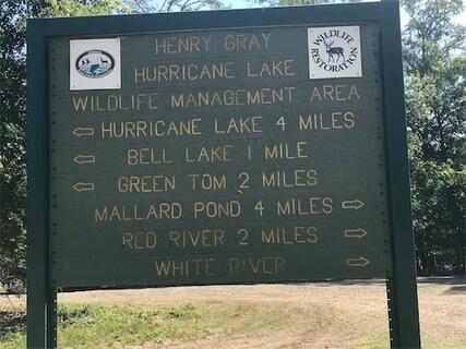
The area consists of 17,000 acres of prime bottomland hardwoods habitat. The area has numerous sloughs and flats throughout and several ridges. Elevation ranges from 190 to 210 feet above sea level. The White River bound the WMA on the east and the Little Red River separates approximately 4,000 acres from the main body of the acreage. Glaise Creek is another main tributary located on the area. The WMA also has several oxbow lakes, the main ones being, Big Hurricane, Little Hurricane, Big Bell, Little Bell, Whirl lake, honey Lake, Big Brushy and Mallard Pond.
Location
This area is in White County, 5 miles east of Bald Knob and 3 miles south of state highway 64.
Restaurants and Other Facilities
Bald Knob is the nearest town with restaurants, motels and places to obtain supplies. Bald Knob is approximately 10 miles from the area headquarters. There is one pavilion built by the Hurricane Lake Bowhunters Association and donated to the AGFC. Also there is a 28-target field archery range available to the public.
Safety
During the summer and early fall, bring plenty of mosquito repellent as the mosquitoes are usually plentiful. Most roads are open to the public and are all-weather gravel roads. Visitors should exercise great caution when traveling these roads, which are narrow and not built for speed. Also, if visiting the area during July, August or September, sportsmen should take extra precautions and watch for log trucks. The areaês many unimproved roads are off limits to vehicular traffic, they are clearly marked with "Road Closed" signs.
Why? By checking in after you’ve visited a place you let others know this place is still functional. You can also add or correct any information.
Latest Check-Ins
This is an active hunting site. We pulled in and it seemed fine but soon after a raccoon hunter arrived. And advised that there would also be duck hunters everywhere in the morning. So we left.
Report Check-InCamping
There are 35 campsites available to the public on the WMA. All sites are primitive and are maintained by area personnel. The sites are marked by signs and/or ringed by blue paint and are located at the following places: Bolie Pond, along the entrance road, headquarters, Three Sister Lake, along Glaise Creek, Honey Lake, Whirl Lake, Big Bell Lake, Big Hurricane Lake, Willow Pond, White River, Holland Beach, Red Rivers Boat Ramp, Mud Pond Slough, Mallard Pond, at Nimmow Access Area, Cypertês Bluff, Spanish Grant, Deep Bank Slough and at Georgetown Access Area. No other accommodations exist.
Description
The area consists of 17,000 acres of prime bottomland hardwoods habitat. The area has numerous sloughs and flats throughout and several ridges. Elevation ranges from 190 to 210 feet above sea level. The White River bound the WMA on the east and the Little Red River separates approximately 4,000 acres from the main body of the acreage. Glaise Creek is another main tributary located on the area. The WMA also has several oxbow lakes, the main ones being, Big Hurricane, Little Hurricane, Big Bell, Little Bell, Whirl lake, honey Lake, Big Brushy and Mallard Pond.
Location
This area is in White County, 5 miles east of Bald Knob and 3 miles south of state highway 64.
Restaurants and Other Facilities
Bald Knob is the nearest town with restaurants, motels and places to obtain supplies. Bald Knob is approximately 10 miles from the area headquarters. There is one pavilion built by the Hurricane Lake Bowhunters Association and donated to the AGFC. Also there is a 28-target field archery range available to the public.
Safety
During the summer and early fall, bring plenty of mosquito repellent as the mosquitoes are usually plentiful. Most roads are open to the public and are all-weather gravel roads. Visitors should exercise great caution when traveling these roads, which are narrow and not built for speed. Also, if visiting the area during July, August or September, sportsmen should take extra precautions and watch for log trucks. The areaês many unimproved roads are off limits to vehicular traffic, they are clearly marked with "Road Closed" signs.