Check-Ins
| When? | Who? | Comment | Place | Location |
|---|---|---|---|---|
|
gunnarbrenne
|
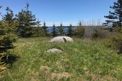
Wonderful wildcamp where overlanders will be in peace since the road is in pretty bad shape. A bench is provided, and a nice firespot. If I had to pick on anything, the Creek beside the road is a bit loud in our flip-up-tent. |
A grass spot next to the ocean | 68.95517, 15.44094 | |


|
||||
|
ldimmler
|
Great spot. No line, quiet. Close on/off interstate. Left $5.00. |
City Dump Station | 42.92537, -123.27569 | |
|
swelch22799
|
This place is permanently closed. |
Walmart Arden | 35.45514, -82.52272 | |
|
Sha1ena
|
This place is permanently closed. |
Riverside | 46.58017, 7.28059 | |
|
Txabola
|
Access after or before the tunnel. Once on the dirty truck, if you take your right, crossing the bridge, you reach the right side of the beach without trees. Taking the left you get the trees . Is not posible go by car from left to right because of a narrow river |
Lagoon | 36.29678, 33.84721 | |
|
instgram.com
|
Closed due to Covid-19 |
Dru Barber Park Campground | 38.94374, -120.76629 | |
|
sabravalee
|
Large pull out on FS 117. It’s not the most scenic site but there’s a nice half circle rock cliff to make it feel private. FS 117 camping was packed when we visited so we were lucky to find this spot. Large enough for rv, tents, overlanders. Plenty of rocks for fire ring, wood for gathering. Road was quiet at night. 2 bar WiFi |
FS 117 | 33.42012, -105.70731 | |

|
||||
|
davidrigal
|
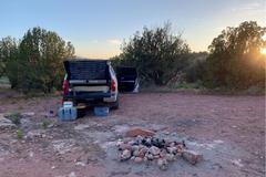
Ok for one night but no longer. At end of the road there's a little river and it's more quiuet.Bit trashy but nice (artificial) lake, lots of birds and good stars. Also, many cars and barking dogs all over the valley. Ok for one night. |
Lots of wild camping space by lake | 42.78733, 18.89636 | |
|
Van Girl76
|
Makeshift camping spot at the highest spot in Kentucky. There is a FAA radar dome and the site of one of the first cable systems in the US. The camping spot we used is in between those two. The road getting up here was gravel and it was decently maintained up until the last 0.2 beyond the campsite up to the cable tower/plaque. We got up with without 4x4 in a Fore Transit 350 Eco. There are bears everywhere. We saw two on the road coming up and one at our campsite after dark that lingered so we ended up going inside. This seems to be a popular spot for locals going beyond the gated road on quads. Version signal on and off. Decent spot if nothing else around. |
Black Mountain | 36.91547, -82.89294 | |
|
gesumo.de
|
This place is not spectacular but good for a night.
|
Mountain pass between Dascht-e Lut and Kerman | 30.15860, 57.40401 | |
|
gesumo.de
|
very good water quality with good pressure. 1/2" thread. |
Syrch : Water tap | 30.20182, 57.55964 | |
|
gesumo.de
|
Maybe that's not the most beautiful place to stay over, but if you like to walk, then go to N 27 to 2700 m, 30.159360 ° N 57.402410 ° O http://maps.google.com/maps?q=30.15937%2C57.40242 and continue with a disturbing fragrance of the mountain herbs! |
Mountain pass between Dascht-e Lut and Kerman | 30.15775, 57.40415 | |
|
gesumo.de
|
it was closed today!
|
Lut_eco_camp 0098/9139970962 | 30.54563, 57.76569 | |
|
roamingyak
|
Worth noting they have some 4x4 trails in the hills behind, including a lake/dam where you can camp. There is a 12km or 26km trail. They are quite steep and I wouldn’t risk my fully loaded Landy with roof tent etc in them just for a bit of fun, but is eas fine my my friends unladen Jerp |
Elisenheim Guest Farm | -22.43693, 17.10068 | |


|
||||
|
roamingyak
|
One cool and funky stand alone guesthouse/building offer by Namvic Safaris, see pictures and details at the link below.
http://namvicsafaris.com/accommodation/windhoek/ |
Namvic Safari Guesthouse | -22.52998, 17.25156 | |

|
||||
|
Lisa Standish
|
This site is for hikers and bicyclers only. In Lockeport, the Shelburne County Rail Trail crosses a long former bridge/causeway. About mid-way on the crossing there is a spit of land on the left that has a short narrow path leading up to the top of a hill where there is a wide clearing for a tent or two. There is a gravel beach area suitable for a rocky bottom swim. Everything is pristine so be sure to respect that and take everything out with you when leaving. |
Rail trail spit | 43.70386, -65.12073 | |


|
||||
|
Lisa Standish
|
This is a wide pull out on the causeway next to the dunes on the only road leading into Lockeport village so there is light traffic. Good place for spending a night and a day on the beach. There is a stairway leading out of the pull out, over the dunes and onto the beach. There is a school playing field across the street and another boondocking opportunity in the parking lot. Everything is clean so please leave it that way. |
Crescent Beach | 43.69669, -65.11674 | |


|
||||
|
senoritajlw
|
Requires a Discover Pass to access park (annual $35, one day $11.50) and then there is a $5.00 (honor system) dump fee. Rinse water available (not potable). |
Lake Sammamish State Park | 47.55542, -122.06691 | |
|
evaandthemechanic
|
Historic abandoned rail station, quiet, arrived during the day slept one night. no problems. 5 min from here you you can visit the the space antennas (stop at the no trespass sign) good view from there. |
Zurich Rail station | 37.18366, -118.26121 | |

|
||||
|
jlghs316
|
As advertised. Not the nicest truck stop, but it definitely works. Bathrooms were clean though! Several other vans and small RV's that spent the night. |
Pilot Flying J | 26.65517, -81.80109 | |
|
hapikamper
|
Great spot! Accessible for tent or car camping. 4 wheel drive not necessary, high clearance- maybe. Bring bug spray and water! |
FR 525C | 34.85268, -111.93270 | |

|
||||
|
nrasscha
|
Nice spot away from the highway, either you can park near the boat launch which offers a Port-O-John, or you can follow the single lane road that can be found to your left as you enter the lot. The road dead-ends to a small plot which had a pre-built fire ring. I stayed here for the night and was never bothered by anyone, just had a train roll through early in the morning across the river from the site. I was able to sleep outside of my car and had a real nice view of the stars. There's a sign on the entrance that says you're allowed to stay 10 days in every 30 day period. |
Just off road on Oregon Trail. | 43.33524, -115.76119 | |
|
ozymandias.steiner
|
Remote place not far from the Interstate 80 - Acces from North is good with 2WD, South only for 4WD.
|
40th Mile Desert | 39.94677, -118.70262 | |
|
ozymandias.steiner
|
This place is permanently closed. |
Huron Beach Road Free Camp | 46.18473, -82.91616 | |
|
jena.meinecke
|
Countless wild camping spots down this road with incredible views of Ephraim. One of our favorite spots so far. Full Verizon signal. 2wd roads suitable for RVs. Lots of locals back here. |
Ephraim Canyon Road National Forest | 39.32543, -111.50936 | |

|
||||
|
dayllen
|
Nice relatively level parking spot for a couple rigs. Off the highway but quite a bit of traffic along the dirt road to what seems like fire wood cutting private land. Parking area just before the gate. |
Outside powers | 42.83199, -123.99967 | |
|
melcruja
|
greatest view! dirt road. extremely popular for the sunset apparently. BLM!! cars and vans ok. narrow road, though a caravan was parked up here. everybody leaves after the sunset. |
TV Tower Road - BLM Land | 35.34523, -120.64354 | |
|
loganrheath
|
Nice dispersed spot with space for small trailers or truck campers. View of the nearby lake. |
Black Hills dispersed camping | 44.00306, -103.86715 | |

|
||||
|
Z White
|
area as described. quiet, tons of parking. |
Dismal Nitch Rest Area | 46.24909, -123.86111 | |
|
instagram.com/LeftyRiders
|
Allowed to sleep here overnight. Just don't park by the exit and leave no trace when you leave please. |
Ashtabula Walmart | 41.88227, -80.74890 | |