Check-Ins
| When? | Who? | Comment | Place | Location |
|---|---|---|---|---|
|
renvaznaestrada
|
bem seguro pessoal do posto gente bia.
|
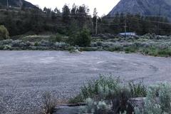
Posto 101 | -27.11553, -48.61002 | |
|
instagram.com/migratory_animals
|
Good for one night sleep. We are in a Sprinter van and chose to stay with the semis. Some noise in the morning when they are leaving, but to be expected. Clean bathrooms and nicely maintained grounds. |
Chambers County Rest Stop | 29.83712, -94.60854 | |
|
wymo823
|
This spot is located on BLM trust land. It is located within the Mt Bike trail system just outside of Price. Quiet, great views. I’ve only seen one other person in two days. Full LTE service |
Overlook on the bike trail | 39.63490, -110.82216 | |

|
||||
|
jsiajr
|
Clearing with one large and one small fire pit. Sort of pitched toward the creek, still beautiful. Pretty quiet so far. |
Castle Creek Rd | 41.16627, -122.43227 | |
|
anthony.maia80
|
Still a very nice place, the water is clear, very easy to go in. And the Highway is very slow so not much noise. (Didn't spent the night because I had to move on) The lake is named Budd. |
Budd Lake - Highway 101 | 47.91329, -84.09870 | |
|
expeditionportal.com
|
There is a fairly large nearly flat (not level) parking lot. It's about 60' wide and 150' long. There's a 2 mile trail to the top of Gibbons Pass. Very quiet although not too far off the highway. We had excellent Verizon service here. |
Nee-Me-Poo Trailhead | 45.75689, -113.94456 | |

|
||||
|
bonjoey
|
$15/night no services great place to stop by if passing by or if you like fishing and boating. Open area so lots of solar. |
Carolside campsite | 51.25613, -111.63372 | |

|
||||
|
mbergeriv
|
I went on Memorial Day. To many sight seeing people. Besides that it’s a beautiful spot. Cell signal is good for AT&T |
TV Tower Road - BLM Land | 35.34444, -120.64277 | |


|
||||
|
BrownPeach88
|
about 1 acre cleared of trees with some shade. rock fire ring. you will need a high clearance vehicle and 4x4 for winter or rainy weather. The trail bushes can get overgrown which will leave pinstripes on your vehicle. |
El Dorado National Forest | 38.62145, -120.43190 | |


|
||||
|
cbsm4
|
Ice spot at the end of the road. Fire pit, beautiful meadow, lots of birds, and deer in the evening. No cell service. |
End of the Road | 44.47278, -120.35806 | |


|
||||
|
natalee311
|
Quiet, safe spot for a few nights! The staff are super sweet and friendly! Just be sure to check in before 6 pm when they close. They are a part of Harvest Hosts. The bathrooms are super clean and it’s a good spot to get breakfast in the morning. Good WiFi! Also do yourself a favor and get a bottle of their label Pinot Noir. |
Blue Heron French Cheese Company | 45.46689, -123.84262 | |
|
h_wuensche
|
French Restaurant in Addis.
|
Louvre Hotel and Restaurant | 9.02496, 38.78709 | |

|
||||
|
jlghs316
|
Spent a rainy night here along the road east of the parking lot. No issues to report. |
Parking near pompano Beach | 26.23069, -80.09907 | |
|
nrasscha
|
A great place to rest before entering Yellowstone! Spent two nights here with no trouble, a few people passed by but had their own agenda. Pre-built fire ring and Teepee can be found here, if the structure is gone there's supplies to rebuild a new one. In terms of water there's a marsh not too far from the site. No service and you'll have to dig your toilet. |
Meadow Teepee site | 44.08021, -110.97946 | |
|
bea.the.beast
|
Just off the highway yet no real traffic noise. Surrounded by nature, and a trail head where the board walk is beautiful (not a super popular trail, so not too much in and out traffic) . No signs against camping or overnight parking. No amenities. We actually arrived early evening and took our time the next morning with no issues at all. |
Pointe-Yamachiche | 46.26555, -72.80971 | |

|
||||
|
aclancey
|
On Powerhouse Road, take the last left before the BC Hydro Facility at the end of the road. There are several flat spots: riverside, large, small, covered. A few friendly locals with their dogs visited around sunset. |
Fraser River Lillooet | 49.28968, -123.13441 | |


|
||||
|
aasartori72
|
Little undeveloped site right before West Fork Foss Lakes Trailhead parking. Down the hill on the right. Hill was muddier than road, so may not be ideal if rainy. Enough room for one vehicle, but probably not a camper or RV. Nice fire pit and clean area. Pit toilet at trailhead, if needed. |
West Fork Foss Lakes | 47.63633, -121.30317 | |

|
||||
|
lee.myrah
|
One of the few campgrounds open during this pandemic. But the washrooms both in the campground and in the visitor centre are closed - so, self contained units only. If you're not self contained you will be asked to leave. Visitor Centre closed and no wifi password posted. Slow wifi at the library, a 5 minute walk into town. CBC News at 99.1. |
Tales and Trails Campground, Longview | 50.53435, -114.23198 | |
|
milesmcbeam
|
Might not be for everyone but definitely will take in and care and love anyone. I was afraid it would all be fake when I got here, and even though most everything is closed down because of the coronavirus and due to it being the off season it is even better than anything the internet has to say. |
Slab City | 33.25791, -115.45743 | |
|
kingn26
|
Petit parking tranquille, proche d’un parc et avec vue sur le fleuve. Tables de pique-nique et aire de jeu. Passage pendant le COVID-19, pas d’eau ni de toilettes et les jeux fermés. |
Parc De L'anse Benson | 46.75324, -71.24900 | |
|
s.lesliemcr51
|
Large dirt lot located directly south along the fence line from the Horsemen's Center Park. Pulled into the dirt lot right as the gates for the park were being locked (9pm) and joined 2 other vehicles already in the lot. There looks to be some flat ground closer to the rocks to pitch a tent if needed. The dirt lot is a little rutted, but had no issue with a 2 wheel drive sedan. Nothing glamorous, but provided a dark spot to get some rest. |
Outside Horsemen's Park | 34.48257, -117.13260 | |


|
||||
|
koureasn
|
Nice beach, also has a place to place the tent among the trees. Fresh water for shower was closed! |
Sandy Beach | 37.09088, 21.58292 | |

|
||||
|
blair
|
A gravel lot as well as a dirt are to park parallel on along the road.
|
Beach Pullout near North Cove | 46.73116, -124.05943 | |
|
lme68vw
|
Rocky road up but so worth the views. Lots of places to camp for free!! |
Lime Creek Road | 37.65437, -107.80187 | |

|
||||
|
tobiastrainer14
|
nice campsite, very nice showers and toilets. Kitchen available. 10 dollars for a tent. |
Established Campsite | -20.00755, 146.41406 | |


|
||||
|
holmesbryon
|
Lots of dispersed camping along the canyon rim. Lots of people too. It was a beautiful spot got there in a 2wd E-150. |
Picket Wire Canyonlands Overlook | 37.64347, -103.57983 | |
|
blt2rok
|
Nice campground in the river. plenty of space,good showers and toilets. Place to wash dishes and stuff. I think it would be crowded on the weekend during the summer but plenty of space to spread out. Very clean and kept up by a campsite host. Free. |
Wilderness Landing | 30.80201, -86.76829 | |
|
dylanguntherj
|
Stayed here a couple days and set up a tent, nice and quiet, a few people drove past during the day but it was Memorial Day weekend so I assume they were camping as well |
Logging road campsites | 45.81778, -123.50787 | |
|
BeardoMcGrath
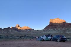
|
Camped here for one night on the Sunday of Memorial Day weekend. Due to COVID closures in Moab, this area was super busy, according to a some folks we chatted with more so than they had ever seen it. However there are lots of places to camp on this road. This particular spot had nice views, but is not very protected from the wind and not recommended on windier days. There is a path nearby down to the river but no easy spot to get in. |
Mexican Mountain Road along San Rafael River | 39.07500, -110.64472 | |
|
||||
|
lesterthedog
|
There are quite a few sites scattered along this road. Decent gravel road. Many hiking trails. |
Canaan Loop Road | 39.09525, -79.44110 | |

|
||||