Check-Ins
| When? | Who? | Comment | Place | Location |
|---|---|---|---|---|
|
esmeralda.life
|
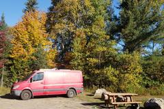
Stayed here 2 nights at the primitive campground and it was super quiet and pitch dark at night. Beautiful night sky, interesting landscape, good mountain biking and some trails for hiking ( many are overgrown after the first couple miles in). Unexpected clear running water in the river in October. Nice spot. |
Arroyo Seco National Forest | 36.23240, -121.48329 | |
|
pqelasoviaja
|
Passamos o dia estacionados na frente da Playa Del Rivero sem nenhum problema. Mas como há placas proibindo motorhomes, viemos dormir nessa ruazinha atrás da dunas. Super tranquilo. |
Along dunes quiet wind shaded spot | -34.04957, -53.54499 | |
|
umersaqib160
|
The location pin is not correct but you have to take the off-road next to the hair pin and not go through the bridge. the place is nice. We heard some animals but had no bother. Fishermen till the evening but they are at a different spot. Fine for big rigs and to pitch a tent too. |
Lakeside camping | 37.90141, 27.59920 | |
|
||||
|
richinsgirl
|
Multiple massive parking lots available for overnight camping! Beautiful area, very calm, hardly any people. There is a train that passes occasionally not-too far off that honks like 30 times haha but we'd definitely stay here again. |
Confluence Park | 38.75039, -108.07500 | |
|
||||
|
oriental.lily
|
Free water towards the back of the office. Plenty of space. |
BLM office in Hanksville | 38.36671, -110.71747 | |
|
oriental.lily
|
Easy access from the highway. If you park on the hill, you have views of the town below. |
BLM Hanksville | 38.38296, -110.72475 | |
|
r8yQqy6zELKsPFAdabwv
|
Nice quiet FS campground with limited services in the off season. No water or electricity. Vault toilets but bring your own TP. Minimal road noise at night. Normally $12/night in the off season but only $6 with a pass! |
Haviland Lake Campground | 37.53406, -107.80710 | |
|
||||
|
floriofpt
|
Clean, quiet (for a rest stop), safe. Full 5G w/T-Mobile. |
Danbury rest area | 41.38917, -73.52044 | |
|
sending.it.south
|
This campsite is down a slight graded hill from road to a flat circular clearing approx 50m wide. Most of the boondocking on Road 71 was inaccessible for our van due to the approaches or the actual sites being very muddy. However the entrance to this site is graded gravel and the large clearing allows the soil to dry much better than the other sites. A large stone fire ring in the middle. there is a turn around that could accomidate a RV. This site is large enough for 5 vans. |
Large, Flat, Open Campsite | 43.06096, -72.98723 | |
|
rob
|
Outstanding spot to fill up on gas, grab supplies, as well as get air and water. They have a propane fill station as well as a hose to fill up your potable water. Great place to stop. |
Pardners Mini Market and Gas | 48.46745, -120.17537 | |
|
RunningGunExpedition
|
Got kicked out by CHP around 11:10 cause someone driving by complained there were cars parked there. Most of us had newer vehicles and were very self contained so I was surprised when they said someone had called in. Ended up moving to a spot in Los Osos nearby that I will add as a location if all goes well for the rest of the night. |
Pullout on #41 | 35.38455, -120.84909 | |
|
ratunks
|
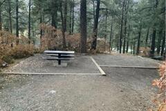
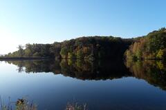
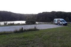
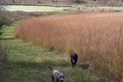
Beautiful spot. I stayed 2 nights with my dogs. There's a fire pit and picnic tables. Would be nice to kayak. |
Jones Creek Pond | 41.87148, -95.92557 | |
|
||||
|
plourdebenoit
|
Chambly Fort city parking. 2 places for bus. Near water. Quiet. Use respect for other please. |
Chambly | 45.44835, -73.27821 | |
|
||||
|
Deb
|
Going to add comment here in a bit - am checking out how I can see this spot in my mobile app |
Blankenship Bridge | 48.46335, -114.07280 | |
|
aw.01.awetzel
|
Parking lot next to small park with playground for kids. Just a short walk to the beautiful Bayview Park. Lots of picnic tables and you can charge your devices at the end of the pier (left side of the park at the "gazebo"). People start coming early in the morning and leave late, but overall very quite and way nicer than the Bayview Park parking lot. |
Pier 4 Parking Lot | 43.27307, -79.86586 | |
|
atfrostedlens.com
|
Currently not usable. The handle on the tap is missing so can’t open it |
The Information Centre | 54.42676, -126.62362 | |
|
pmcneill76
|
Great spot for the night. Lots of trucks but we parked in the car area and it was very quiet. |
Eastbound I-40 Rest area | 35.36724, -93.34473 | |
|
vagavaughans
|
As described a beautiful view spot. Large parking area. When we arrived at 5pm we were the only ones here. Not alot of traffic going by on a Weds evening. |
Port Orford Sunset free | 42.72202, -124.46669 | |
|
||||
|
Durgalein
|
Owner is there but ignored us. Later we heard it's close because of Covid. The street is not passable, even not with a 4x4. We are in the neighborhood hotel Venecia, very nice! You have to use the street with the bridge to get there. |
Hostal Chico Largo / Hotel Finca Venecia | 11.48134, -85.63957 | |
|
faulknergail
|
Great free spot for overnight in Val Morin. room for 2 RVs. Set up by rhe municipality. picnic tables, portapotty and outdoor sink. Next to a park, level, and quiet. |
Parc Legault | 46.00984, -74.19624 | |
|
||||
|
dovellandrew
|
Attempted in my 2wd 1984 VW Vanagon... Could not climb the steep gravel hill. Do not recommend if you dont want to get scratches. |
South Fork Trinity River | 40.88503, -123.60267 | |
|
Nomad N Rad
|
This is also listed as a formal campsite but I wanted to pin it again so people would know it’s free.
|
Hank snow museum and free RV park | 44.04522, -64.71922 | |
|
ShelleyTheShed
|
Lovely new Fig Tree Camp to replace the old flooded one. Really lovely spot amongst big trees with a stream running through. Spent 2 nights here. No facilities. |
Lake Bogoria | 0.20966, 36.09866 | |
|
GreyAndGreen
|
Lot perimeter is mostly sloped and/or obstructed by trees, so we took up space in the inner lot. (Not our favorite.) There was one other rig here and some man made noise including their generator and the road. Still, a good place to restock and rest for a night. |
Walmart | 32.83237, -109.73223 | |
|
draganirob
|
I would not camp here. Checked it out, got completely lost. There is an endless network of roads out here, almost none of which are on Google Maps. Huge piles of trash / destroyed RVs at most sites. Drove till the end of one dirt road and saw a group of cars, pulled up to ask directions and was met with the dirtiest, scariest looks I’ve ever gotten. Total meth head vibes. Still took me another half hour to find my way back to the highway after that. There are plenty of campsites, but this is only for the particularly brave. Scariest moment of my 2 month car camping trip so far. |
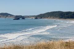
Forest Road near Canon Beach | 45.86482, -123.76613 | |
|
Mark MOtsko
|
Clean campground but very noisy due to interstate close by. Dry camping is at the designated loop right next to the interstate. Expensive |
Windmill state recreation area | 40.70826, -98.83671 | |
|
joneswhyte
|
A nice site. Nice walking on the dirt roads and trail bed. Swimming is nice but the bank has eroded and the tree that held the swing rope has fallen into the river. Highway is close but traffic lightened up overnight. |
Opeongo River site | 45.50626, -77.94671 | |
|
aluminiumlinings
|
Big parking lot, clean bathrooms, actually called “The Last Spike” |
The Last Spike | 50.97631, -118.72368 | |
|
ehowie42
|
Big lot, much quieter than a typical Walmart. There were a few other vans parked here and a couple RVs Pulled wifi off a Freddy's nearby. Lot has some slant to it but nothing crazy |
Cabela’s | 38.02607, -84.41140 | |
|
xblackwolf20x
|
Update: it’s only camping in designated area. It’s belong to National Park. But the season is closed for this. Any car can do without 4x4 but don’t go opposite side. It definitely need 4x4 and little rough road. There few spot can parking but will not perfect “flat”. Just one night will do. |
Lk. Mead National Rec | 35.93650, -114.63362 | |
|
||||