Check-Ins
| When? | Who? | Comment | Place | Location |
|---|---|---|---|---|
|
richardvanboxtel
|
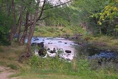
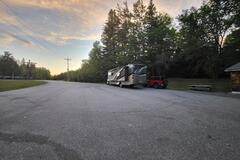
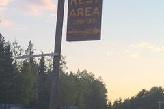
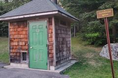
A paved parking lot large enough for a large RV. Next to a road with some traffic noise. Access to a nice stream. Picnic tables and a typical park toilet. No public water supply or ther hookups. |
Crawford Rest area | 45.00095, -67.61832 | |
|
||||
|
riterb97
|
Visited for 3 nights. Staff very friendly and ablusion facilities very neat and clean. Campsite 21 were our favourite |
Algeria Cape Nature | -32.37464, 19.06319 | |
|
jennkdouglas
|
Maybe the water is shut off for winter but the pump is NOT working. |
Smith's Gas Station | 35.66043, -105.98059 | |
|
exp01020-fg
|
Sign says Day Use Area, No Overnight Camping |
Padilla Bay Trailhead | 48.45699, -122.46617 | |
|
jubiladosxelmundo
|
Camping muy amplio, con árboles y asaderas, electricidad, baños muy limpios y ducha caliente, supermercado a 100 metros. 1250 pesos Argentinos por día 2 personas y motorhome. |
Camping Municipal Carlos Xamena | -24.81227, -65.41902 | |
|
||||
|
TraansitandosemFronteiras
|
Lugar tranquilo pra dormir. Procure pelo Giliard, ele organiza e indica o melhor local para ficar, mostra onde está o ponto de água e luz (110v e 220v). A permanência permitida aqui é de segunda a quinta, pois é o estacionamento privativo para ônibus.
|
Rodoviária | -21.10941, -44.17440 | |
|
ronstrayer
|
Can't add much to previous reviews. Pretty open with space between spots, a little dusty, but not the worst I've seen. No amenities. Quiet. |
Dispersed Camping near Sisters | 44.24809, -121.49691 | |
|
astronaut_ing
|
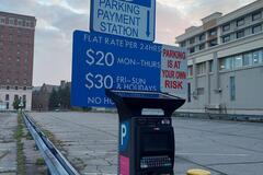
cornered by a building and an intersection, two pay stations at each end. Bought the $20 weekday rate ticket for 24hrs, I was the only car in the lot in the morning. |
24hr parking - Niagara FallP | 43.08372, -79.06186 | |
|
||||
|
chamberlincd
|
Located about 500 feet off the south side of the road, which is good gravel for about 3 mi if coming from west. This spot is a bit messy - looks like it gets used as a gun range. But it's got a really nice view. |
Lower Crab Creek Road SW | 46.82860, -119.80571 | |
|
gogogauthiers.blogspot.com
|
This place is in wrong location - it is located at 49.86942, -120.56725 |
Bluey Lake | 49.86942, -120.56725 | |
|
plbchauffvalcartier
|
Just off the highway quiet place asphalt parking dump station . Few trucks at A&W tend to be noisy backing up nice stay over all, For one night only. |
White River Tourist Information Centre | 48.59222, -85.27649 | |
|
rpmelicher
|
I don't expect this place to remain open long with the amount of garbage and seemingly permanent residents. That being said, it was convenient for 1 night. |
Gee Creek Safety Rest Area, South Bound | 45.74892, -122.66494 | |
|
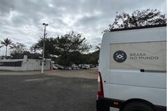
brasanomundo
|
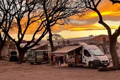
Lugar muito bom! Tranquilo, com vários motorhomes. Tem dois estacionamentos, cabe carros grandes.
Tem parquinho para crianças e uma área bem ampla. Adoramos o lugar.
|
Parking of Prainha Vila Velha | -20.32841, -40.29169 | |
|
||||
|
PEDARO
|
Best option in town, we were welcome👍
|
Great Northern Casino | 55.17790, -118.82559 | |
|
lorriam
|
We passed the location indicated on ioverlander and went to the end of the point. There is a large fairly flat parking lot just under the lighthouse. Very quiet area but no amenities. A few locals came by to walk their dogs. coordinates: 47°14'17.0"N 54°00'49.2"W |
Point Verde | 47.23339, -54.00742 | |
|
fhsosa
|
This plaza has electricity available and whater |
Estacionamiento Plaza Central Yacanto de Calamuchita | -32.10505, -64.75474 | |
|
||||
|
hobogoessolo
|
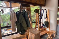
The visitor center is open . You can have breakfast or burgers or ciabatta. Even soup . Walks can be paid here by creditcard
We did camp here with RTT. They are still building . |
Uwinka Visitors Center, Nyungwe National Park | -2.47831, 29.19971 | |
|
||||
|
Kuniontour
|
The location is in the middle of the dessert |
Cloud forest | 33.63566, 54.02336 | |
|
hobogoessolo
|
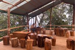
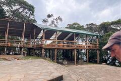
We camper here with RTT next to the wooden structures for tents. Very quiet during the night. |
Uwinka Campsite | -2.47828, 29.19973 | |
|
melgraph
|
Très bel emplacement avec vue sur le lac. Tranquille mais bruit de la route raisonnable mais présent. Un peu trop de papier de toilette un peu partout, svp ramassons nous pour le bien-être de tous. Leave no trace:) |
Lac Resimond | 48.43409, -70.45606 | |
|
||||
|
marc.loosveldt
|
no overnight for cars and campers |
Knockfarrel | 57.58985, -4.50671 | |
|
offroad-travel.net
|
tel.0977414601
|
Diesel Mechanic | -15.28997, 23.15197 | |
|
coull13
|
We visited and did a guided walk of Rhino trail, P50pp entry + P125 for guided hike - you have to walk with a guide now. Beautiful rock paintings and scenery, the Male is the highest point in Bots! The road is pretty terrible to get there, but worth coming if you are passing by to Mohembo boarder post. |
Tsodilo Hills (museum and bushmen paintings) | -18.78354, 21.74155 | |
|
||||
|
Adriaan&Isabelle
|
We had our CV axles and front brakes replaced (parts were sourced elsewhere beforehand), changed fluids and performed regular inspections. All done in one day by very knowledgeable Palle Hansen. |
Mikkelsen Auto | 50.73753, -113.95760 | |
|
Chicksdoit2
|
Nice campground with showers. You MUST hike the gorge! |
Watkins Glen State Park | 42.36453, -76.88799 | |
|
JC
|
This place is in wrong location - it is located at 29.64827, 52.31645 |
Level area, off the road | 29.64827, 52.31645 | |
|
Travelin-Tortuga
|
There’s a new sign stating, “Day use only. No overnight parking “. We stayed here with no trouble about ten days ago, but returned for another visit to find this sign. |
Windsor Falls | 48.92442, -55.65169 | |
|
ByChance
|
Not much better than a rest area, but it’s convenient and there is a restaurant. Many campers look like they are here for a while. Stayed because there were shade trees. Ok for a night. |
50,000 Silver Dollar Bar | 47.38782, -115.39888 | |
|
BeingHumanRV
|
These coordinates get to you the main area but not quite to the camping area. Go past where the coordinates take you and make a left at the end of the street. You have to go downhill on a somewhat skinny and steep road to get down to the bottom. I don’t think really big rigs would be a good idea on that road coming down. Better suited for rugged shorter trailers and vans. |
Little farther up the road from “Arkansas River” post | 38.87845, -106.14952 | |
|
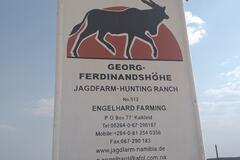
onlyME
|
Turn off from C33, about 10 km south of Kalkfeld.
|
Kovahange Safaris &Guest Farm | -20.94157, 16.14793 | |
|
||||